Regional Park Rhön - UNESCO Biosphere Reserve, Nature Park and most important: Home

Welcome to our Community
Wanting to join the rest of our members? Feel free to sign up today.
Join now!
EXIF
Not applicable

Baenki

New Member
1
Sep 9, 2020
182
247
452
Hey everyone!!!
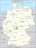
As I am lucky to live inside a UNESCO Biosphere Reserve, I thought I would share some spots and impressions from there and give an overview of the region. As most of the pictures I take don't fit the macro bill, I will dedicate this thread to them. Here I'll do different posts, showcasing individual locations, flora and fauna I photograph and other interesting stuff. This first post I'll treat as an overview of the individual posts, which I will link in the following...

Table of Contents:
0. The Rhön - an overview
🆕
1. Locations

- Rotes Moor (bog) and Heidelstein mountain 🆕
2. Flora and Fauna


Enjoy!!! ;)
I'll update this thread as I visit new spots and take more pictures.
 
Last edited:

Baenki

New Member
1
Sep 9, 2020
182
247
452
The Rhön - an overview

View attachment 15330The Rhön is a region, mittelgebirge (low mountain range or highland) as well as a UNESCO Biosperhere Reserve located in central Germany and split between the three federal states of Bavaria, Hesse and Thuringia.

The biosphere reserve spans 2433sq.km and includes all of the 1500sq.km mountain range. About 3% of the reserve are designated as core protection area where no land use for agriculture or forestry is allowed. Further 22% of the area are designated for upkeep of natural areas which resulted from land use and wouldn't retain their characteristics if completely unused. In these areas some mild land use (e.g. grazing by cattle and sheep) is allowed. These areas include most of the typical calcareous grassland which would otherwise turn into bushland. The rest of the reserve is declared development zone, where normal land use is allowed. This area also contains the towns and villages.

The Rhön features the aforementioned grasslands, beech forests and was formed by volcanism. It is a popular region for biking and hiking trips.


Location of the Rhön in Germany (Source: Wikipedia)

Back to the Table of Contents
 

Attachments

  • Karte_Biosph%C3%A4renreservat_Rh%C3%B6n.png
    Karte_Biosph%C3%A4renreservat_Rh%C3%B6n.png
    307.6 KB · Views: 0
Last edited:

Baenki

New Member
1
Sep 9, 2020
182
247
452
Rotes Moor and Heidelstein

rotes moor.jpg
Moorweiher - artificial pond resulting from peat cutting.

The rotes Moor (red moor) is a raised bog in the hessian Rhön and is the second largest bog in the region. It is a protected area open for hiking.
For a long time of it's history it was used as a source for peat, the cutting of which was only stopped in 1984. In the process of sourcing peat, a large part of the bog was altered from it's natural state and damaged. While the peat cutting was still ongoing, the area was declared a nature reserve and measures for renaturation were started, some of which involve rewetting the ground by damming up water and removing spruce forests which grew on the altered areas. Goal of this was to change them into natural decidious forest and meadows. Later on these areas were planned to be turned into bog by allowing the peat cover to form up again. As the production of a natural peat cover can take centuries to millenia, this process is still ongoing.

The moor features a circular hiking part around the central area changing to a walkway of wooden planks, when leading through less disturbed bog area and the typical moor birch (Betula pubescens) forests.

P1010763.jpg P1010755.jpg


Moor birch (Betula pubescens) forest - right: plank walkway; left: a dead treewhich stands in the forest for as long as I can remember

From the moor path you can also branch into another hiking path leading down the Kaskadenschlucht (Kascade Canyon) which features a creek flowing through beech forest typical for the Rhön. The path loops back into the moor.

P1050614_2.jpg
Sorrels (Oxalis) growing on a mossy tree stump in a beech forest, shot at Kaskadenschlucht

Another interesting location close to the bog is the Heidelstein mountain next to it, which prominently features a large transmitter mast of the same name. Leaving the moor behind one can stop at the NABU-Haus (Nature and Biodiversity Conservation Union-House) right next to it, rest and have a beer, bratwurst or some cake before starting the uphill hike towards the transmitter on the 926m high peak of Heidelstein.

P1010775_2.jpg

Heidelstein and transmitter mast in the background of a part of the red moor where peat was cut.

Back to the Table of Contents
 
Last edited:

Jack

Love Macro
Staff member
3 3 1
Mar 13, 2020
11,900
24
8,215
1,339
That's really good info and very interesting places. I would love to have time and visit such of places. By the way, we have king of blog section on site, you can check it here if you'd like Baenki Baenki

 
  • Like
Reactions: Greg Shchepanek

Helix_2648

Real-Typer
Legend TEAM
5 3
Apr 20, 2020
5,566
11
7,751
1,340
Hey Baenki Baenki! Thanks for your fantastic work with all your given information and your pictures! Unfortunately it's too far away for me. I live in Detmold near Bielefeld and we've mostly only agriculture areas. Only a few meadows and some forests. But macro photographs needs only one little but good spot.